Background: Partner Software provides utility companies and co-ops with a suite of tools to plan, construct, and manage various utility network infrastructure elements and systems. Partner Software is looking to explore how the ESRI suite of software and solutions can be integrated with the company’s current GIS system to further meet client needs and provide cutting edge technological solutions. This project developed a proof-of-concept web application for online or offline field design (also referred to as “staking”, field design is the planning of new or update power-lines, transformers, etc. in a larger electrical system). Partner Software has an advanced infrastructure that allows small utility clients to create, manage, and view active utility projects both in an office setting and in the field where internet connectivity is not possible. This system relies on several relational database components that move a “job” through the GIS to allow for complete organization for the clients in their work planning, updating, and maintaining electrical utilities.
Methods: A large portion of this project focused on researching and investigating the various ESRI methodologies, schemas, analyses, and solutions to identify a suitable workflow for Partner Software’s Field Design process. The ESRI Utility Network model schema was utilized to combine industry standards and the necessary fields for incorporation with the current Partner Software system. Beyond the schema and design of the Enterprise Geodatabase that acts as the basis for the final web application, several customized models, including a published geoprocessing service, were developed and deployed to aid in required field design functionality.
Results: The primary results for this project include the Enterprise Geodatabase feature classes representing the necessary Partner Software “Job” components and related attribute data. These results are added to other Utility Network components and served in a customized ArcGIS Online Web Map. This map is finally consumed by the Field Design web application, pictured below.
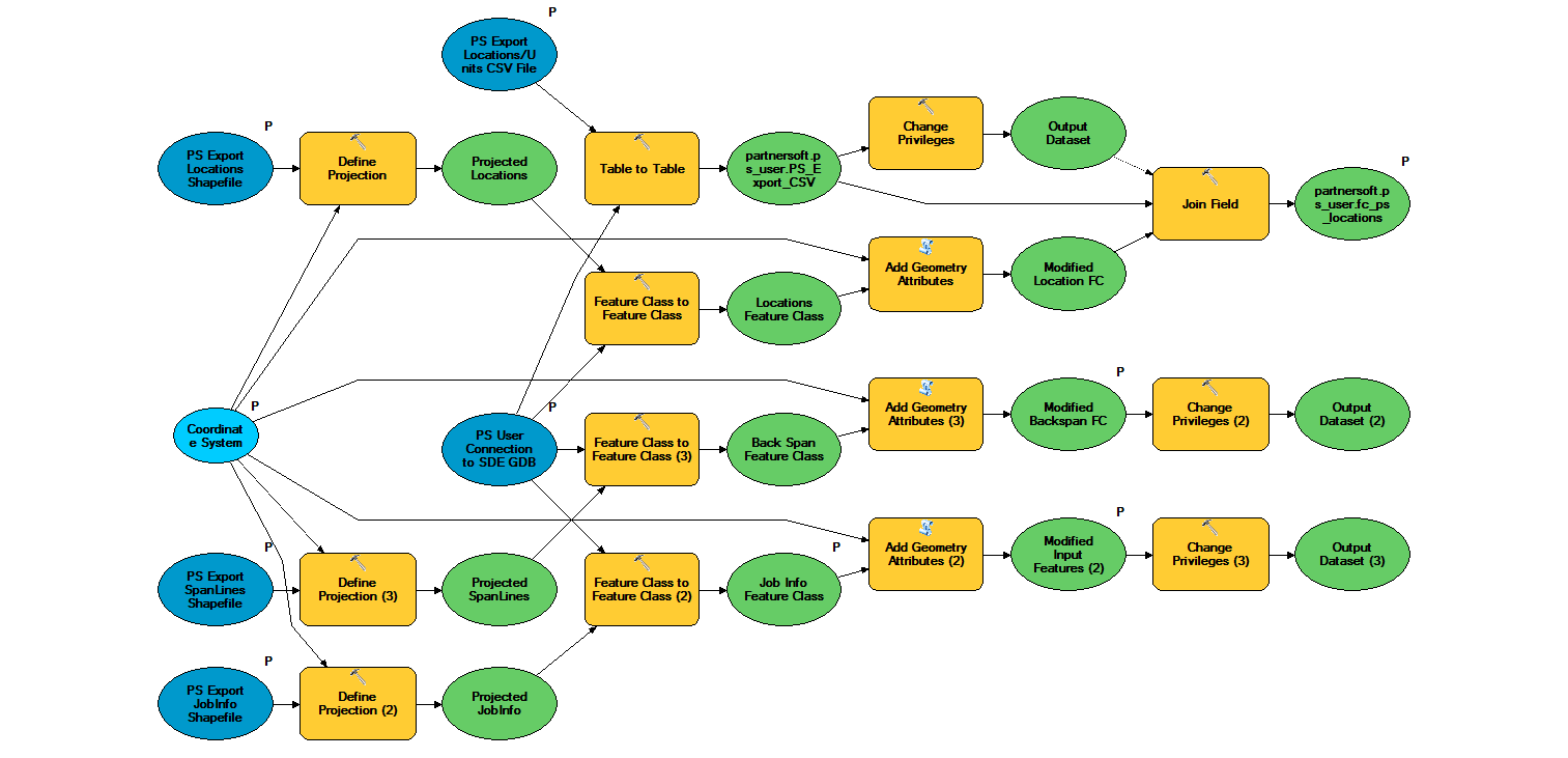

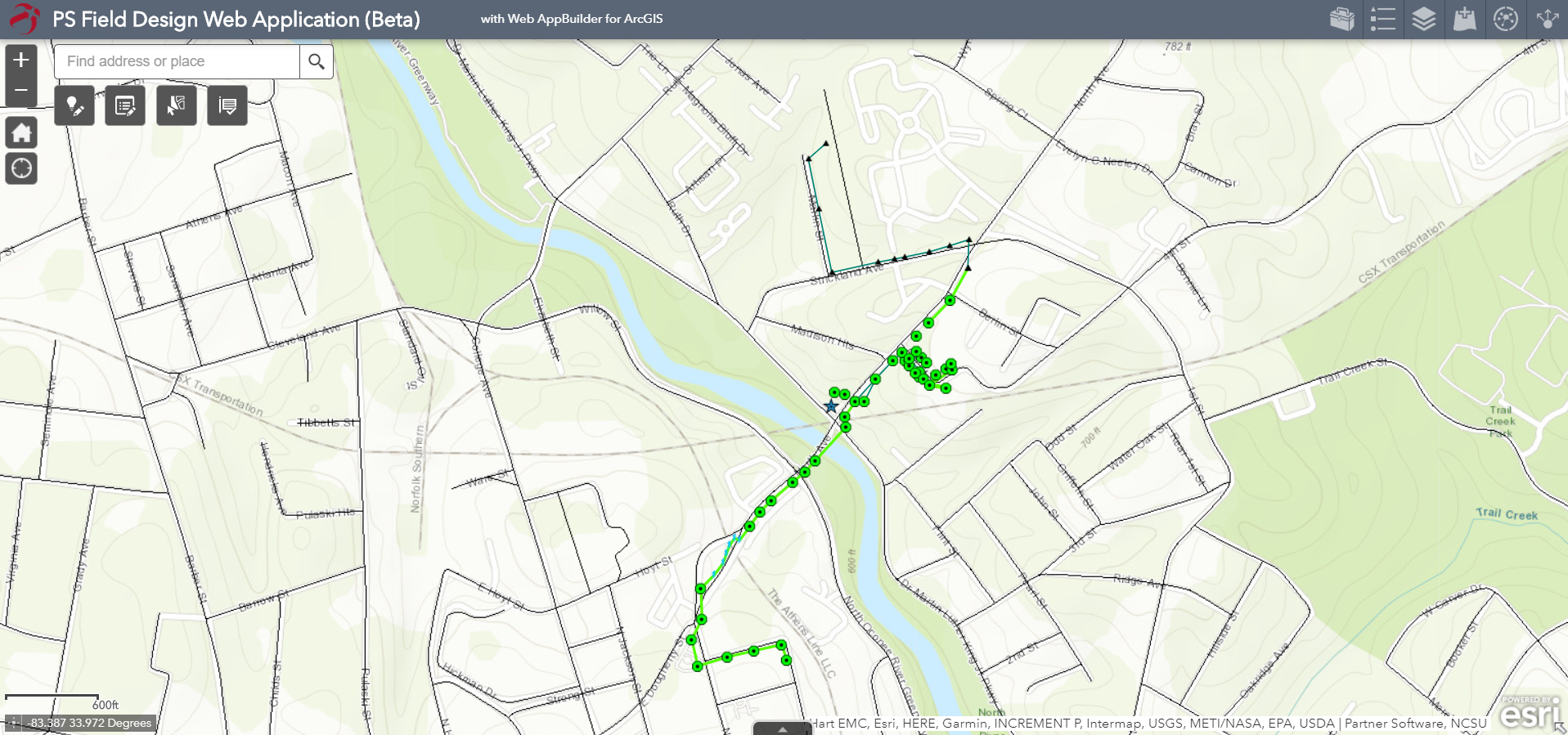
Despite being relatively simple in regards to spatial composition, the “locations”, “spans”, and “jobInfo” feature classes represent nearly all the individual units comprising a Utility Network. The locations act as a ‘bucket’ that contains all the units associated with the pole or other utility support structure included in the location and are connected through spans representing conductor lines or other utility network features. These features can be edited while connected to the internet as well as offline through the Collector for ArcGIS application. The functionality of the Collector for GIS app is invaluable in the field design process. Because the published feature services have sync enabled, Stakers can create, edit, and delete utility network components while in the field and those changes will be synchronized with authoritative data once connected to internet.
Discussion: This project provided a real-world analysis of how companies in the utility industry can leverage the Enterprise solutions of ESRI to mesh their current practices, standards, and data into comprehensive spatial databases that serve Utility Network data to customized Web Mapping Applications.
While the options for generating a viable offline capable Field Design application through the ESRI suite of products are numerous, the decisions made in this project will allow Partner Software to realistically offer their clients the latest technology while maintaining their award-winning functionality and capability. Future work on this project will focus around expanding the Web Applications’ service area, further developing of additional advanced staking functionality, and eventual integration with the rest of the Partner Software GIS system.
Conclusion: The final product for this project has provided Partner Software with a viable Enterprise solution for mobile Field Design as well as providing detailed reports and suggestions on future spatial database implementation.
Acknowledgements: Partner Software LLC, Nate Armstrong, NCSU, ESRI
